Detailed terrain data for navigation
Detailed terrain data for navigation – also called S-102 data – is available for several large Norwegian ports, some narrow straits and some anchorage areas.
As the second hydrographic office in the world, the Norwegian Hydrographic Service is now producing and distributing detailed terrain data based on the standard S-102 Bathymetric Surface.
The Norwegian hydrographic Service produces and publishes detailed terrain data (S-102 data) in areas where there is a particular need for precise navigation, to ensure a safer and more efficient shipping.
Order data Detailed terrain data (S-102)
Detailed terrain data (S-102) can be ordered via Primar (requires user profile).
Primar is an international collaboration that is run on a non-profit basis by the Norwegian Hydrographic Service.
Primar supplies official navigational charts (ENC) from all over the world to international shipping.
About
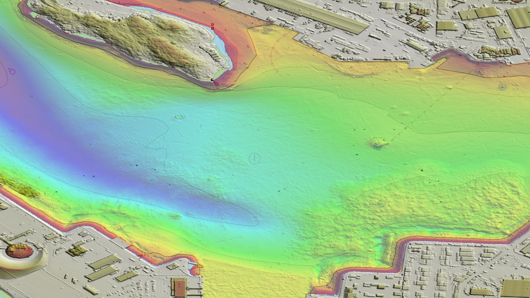
Detailed terrain data (S-102) is a model of the seabed, based on a grid where each cell has a depth value. The model presents the seabed morphology in detail. S-102 provides more information and a more accurate representation of the seafloor conditions than the traditional navigational chart does.
Areas of use
Detailed terrain data visualises the seabed bathymetry and can be used together with official navigational charts and ENC’s for more precise navigation. A detailed model of the seabed morphology is useful for safe route planning for navigators and pilots.
Areas where accurate navigation is important, are ports, harbours, particularly narrow or shallow waters, anchorage areas etc.
Based on reported user needs, the Norwegian Hydrographic Service sends a request to the Norwegian Armed Forces for permits to publish detailed terrain data for navigation (S-102).
Format
In the future detailed terrain data will be used as an overlay to official electronic charts (ENC) in type approved electronic chart display and information system (ECDIS) based on the S-100 framework.
To read this data format, a customized system is required. As of today, there are only a few system suppliers who supply solutions for displaying these terrain data. Contact your system supplier if you wish to use detailed terrain data (S-102).
The pilot service and the Norwegian Coastal administration are already using the terrain data in some of their systems.
Detailed terrain data for navigation (S-102) can be ordered via PRIMAR - Map (ecc.no) To be able to order you/your company must be a registered user at Primar.
The mail has been sent!